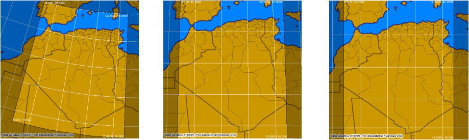
Lambert Conformal Conic (left), Transverse Mercator (middle), and Mercator (right) Projections
Germany Mapped
I chose to locate Germany on the map because I have a personal interest in the country. Not only do I study the language, my ancestors were from Germany. Thus, I sought to gain a better understanding of my heritage by learning more about Germany. Specifically, I can now see where exactly my forefathers came from.
To see an accurate map projection of Germany, I used three different types of projections. I used a Mercator projection, a Transverse Mercator projection, and a Lambert Conformal Conic projection. While all three types gave me different images, I created the image in the same way for all three. I used a website created by Pennsylvania State University called the “Interactive Album of Map Projections.” This site allowed me to type in geographical information about Germany, such as the latitude and longitude coordinates, and then the site generated a map of Germany. The more specific the coordinates, the more detailed the map. After finding out the northern and eastern coordinates of Germany, I guessed and checked as to the remaining coordinates and found the ones that gave me the closest view of the country. The three different projections can be seen above.
The different types of projections certainly had different benefits and drawbacks. The Mercator projection was the most directionally true projection. It gave me a clear sense of where, directionally speaking, Germany lies. With the Mercator projection, it is easiest to visualize Germany in the actual context of a point on Earth, meaning it is easy to understand where Germany is located on the globe (as opposed to the Lambert Conformal Conic projection, which gives a better sense of how Germany is located on the globe). It is also visually pleasing. Likewise, the Transverse Mercator projection is easy to view. The way the country gets smaller and farther away at the top of the projection gives the sense that the map being viewed is not actually a two-dimensional map, but rather a piece of a globe. That also helps when trying to think of Germany as it actually lies, on the round Earth. Both the Mercator and the Transverse Mercator projections also show the boundaries of the different states within Germany, making the maps helpful in seeing boundaries. So I think the Mercator projection would best be used when navigating and the Transverse Mercator projection would best be used when thinking of Germany as a country (either thinking of the divisions within Germany or Germany as related to other countries). Finally, on the Lambert Conformal Conic projection, Germany is angled towards the upper right hand corner of the map. This is as opposed to the other projections in which the top of Germany is pointing towards the middle of the top of the map and the bottom of Germany is pointing towards the middle of the bottom of the map (so Germany is shown straight up and down). This helps to more accurately show Germany as it might appear when being viewed on a spherical object (either looking at it on a globe or looking at it as a point on the Earth from a satellite). Thus, the Lambert Conformal Conic projection would probably serve as the best projection to consult when trying to get a feel for Germany’s relative location on the globe (or even, thinking on a smaller scale, in Europe). Giving Germany’s directional shape helps in understanding where it lies relative to other countries.
When talking about cartography, site and situation are two important geographical terms that, while seemingly similar, are markedly different. These terms both help geographers to get a better understanding of where exactly something is located. In general, site tells geographers precisely where something is located. On a small scale, such as when talking about places in a specific city, the site of something can be its address. When referring to larger areas, such as countries, site would be defined in terms of the specific latitude and longitude of the country. Site can also refer to the physical character of a place. In this instance, when talking about a country, it refers to important characteristics of that country, such as climate, water sources, topography, soil, vegetation, and elevation. On the other hand, situation refers to the relative location of an area. Situation is described by telling where a certain place is in relation to other places. Site is particularly important because it helps people to find unfamiliar places by using known places and because it can help people to understand the importance of the location of a certain place. For example, a person might find the address her or she is looking for because it is located across the street from someplace that person is familiar with. This is an example of situation on a smaller scale. When talking about an area as big as a country, knowing the geographic landmarks nearby can help explain why the country’s political system, economy, and culture are the way they are.
Furthermore, site and situation are more than just ways to identify and understand a certain place. They can affect the very make-up of an area. In Germany, site and situation have an affect on the economy itself. Germany is the third-largest exporter in the world. In fact, exports account for more than one-third of the national output of the country. Situation plays a key role in this. Germany borders the North Sea in the northwest and the Baltic Sea in the northeast. Additionally, some of Europe’s major rivers, such as the Rhine River, the Danube River, and the Elbe River, run through Germany. This close relationship with water (as well as proximity to many other European countries) has traditionally enabled the great exporting capacity of the country. In terms of site, Germany is located in central Europe, meaning it has ample farming ground (though it also includes forests and mountains). This location has enabled Germany to become among the largest agricultural producers in the European Union. Thus, site and situation are major factors in influencing the economy of Germany.
