To access the BatchGeo website which features the actual map, simply follow this web address:
http://www.batchgeo.com/map/39f29653fb4f612a90ef801845316edb
Analysis
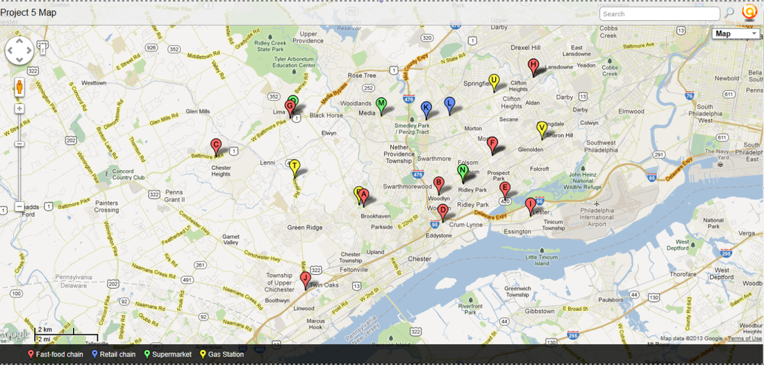
1. To create this map, I constructed a spreadsheet documenting specific stores located within a five-mile radius of my zip code (19086). The services I mapped were McDonald’s restaurants, Target stores, Acme supermarkets, Wawa gas stations. To find all of the different stores located within this area, I used the store locator resource on all of the stores’ websites. After I had completed this spreadsheet, I entered the data into the BatchGeo program, which compiles a map of all the locations. This final product is displayed above and can also be accesses by following the web address located below the picture. Please note that on the map, the McDonald’s are classified in the legend as a fast-food service, the Targets are classified as a retail store, the Acmes are classified as a supermarket, and the Wawa gas stations are classified as a gas station.
2. This service is an application of GIS, which stands for Geographic Information System. GIS is a computer system that stores, organized, analyzes, and displays geographic data. This is different from GPS, or Global Positioning System. GPS is a system that determines the precise position of something on Earth through a series of satellites, tracking stations, and receivers. In essence, GIS records information about the Earth and then displays this information. GIS can record different information, and then this information can be displayed in layers on an electronically generated map. The layers can be turned on and off as desired. In comparison, GPS is meant to pinpoint the location of a certain object on Earth’s surface. GPS is generally used more for navigational purposes.
3. Density is the frequency with which something exists within a given unit of area. In the context of my map (in which the area would be defined as the five-mile radius around the 19086 zip code) McDonald’s has the highest density, followed by Wawa gas stations, followed by Acme supermarket. Target has the lowest density. When discussing density, it is defined more precisely in terms of concentration, pattern, and agglomeration. Concentration is the spread of something over a given area. To be more precise, it refers to the distribution of a phenomenon within a given area. More highly concentrated phenomena will be closer together, whereas a low concentration implies that the phenomena are more spread out. In terms of my map, the two Targets are the most densely concentrated, followed by the Acme supermarkets and the Wawa gas stations (in that order). The McDonald’s have the lowest concentration of the four services featured on this map. Pattern is the geometric or regular arrangement of something in a study area. In other words, pattern refers to the geometrical arrangement of objects in an area. It is helpful in describing where objects are laid out. Looking to my map as a study, the distribution of all of the services seems to be rather irregular. There is no set geometric pattern along which any of the businesses appear to be laid out. Lastly, an agglomeration (in terms of services) is a heap or cluster of businesses in a certain area. In looking at my map, there are several observed trends that could qualify as agglomerations. Firstly, the two Targets are located extremely close to each other, seemingly clustering together along Baltimore Pike. A McDonald’s and a Wawa gas station are also located close to each other in Brookhaven, implying an agglomeration of services in that area (perhaps it is a central business district). Likewise, A McDonald’s is located very close to an Acme supermarket along West Baltimore Pike in Lima, once again implying a clustering of services in that area (perhaps the area is some sort of shopping center). Lastly, an Acme supermarket is located very near a Wawa gas station in Folsom, once again hinting at an agglomeration of services.
4. The Central Place Theory explains the distribution of services, based on the fact that settlements serve as centers of market areas for services. It states that larger settlements are fewer and farther apart than smaller settlements and provide services for a larger number of people who are willing to travel farther. Specifically, the Central Place Theory demands a division of space into geometric shapes (the theory uses hexagons) centered on a central place, which is the market center for the exchange of goods and services by people attracted from the surrounding area. The hexagon marks the market area, or the area surrounding a service from which customers are attracted, for the central place. In the context of my map, it is easy to see the Central Place Theory in effect. Looking at the distribution of McDonald’s, one will note that there are many of them spread out across the area. This is because they are not a service people are willing to travel far to access, and therefore the individual settlements (the different townships, cities, etc.) in the area are all likely to have their own, instead of just one restaurant located in a central area. The same seems to hold true, if to a lesser extent, for the Acmes and Wawa gas stations. While perhaps not every individual area has their own, they are dispersed throughout the settlements, instead of centrally located in larger one. In contrast, the Targets seem to be at the center of a market area. The only two stores in the entire area are located in a central business district of the area. According to the Central Place Theory, this would be because they are a service people are willing to travel longer distances for. While people probably wouldn’t drive twenty miles to get to one, they would be more likely to travel five miles for access, hence their scarcity in the five-mile, 19086 zip-code, area.
